{
Skip to content
{
Skip to content 
Lemosho Route Altitude – Complete Altitude Profile & Acclimatization Guide
The Lemosho Route altitude profile is one of the main reasons why this is considered the safest and highest-success-rate route on Mount Kilimanjaro. With gradual elevation gains and excellent acclimatization opportunities, the Lemosho Route offers a smoother path to the summit—making it ideal for both first-time climbers and experienced trekkers.
For professional guided climbs, safety protocols, and full itineraries, visit Mount Kilimanjaro Guide.
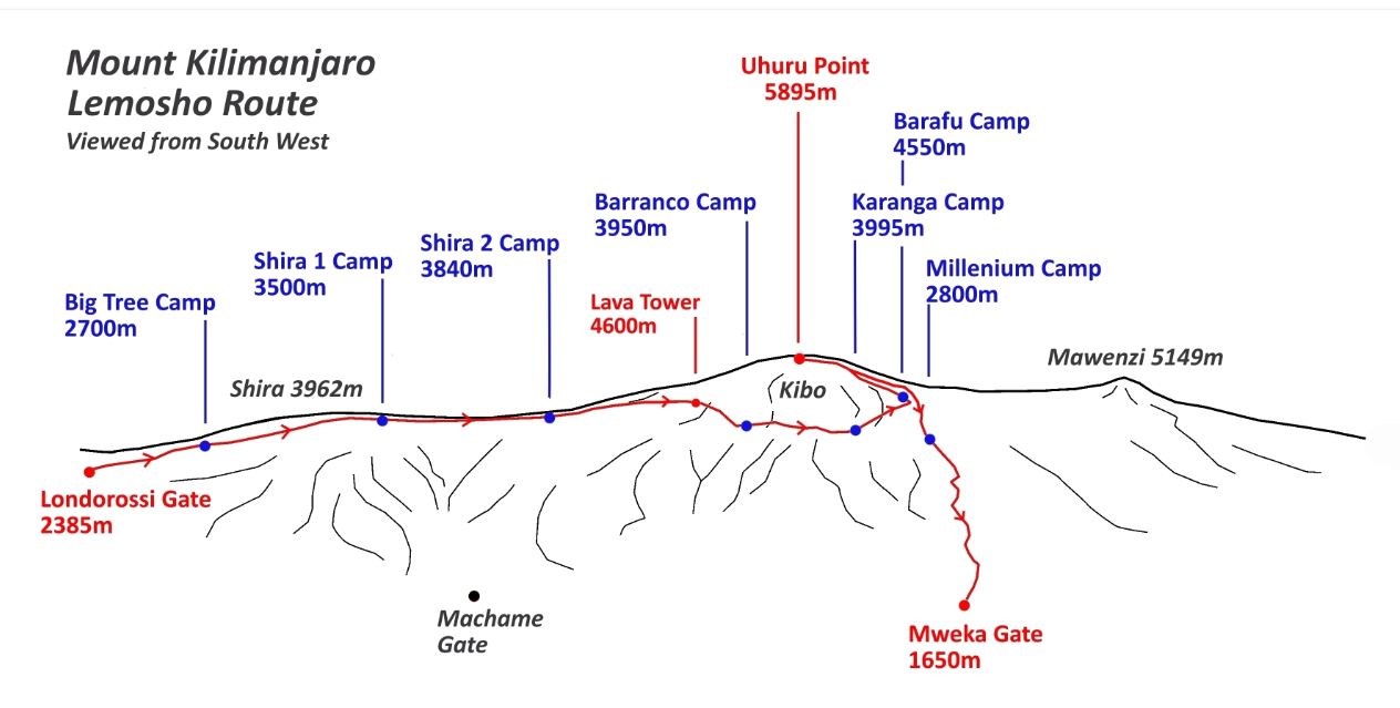
Overview of Lemosho Route Altitude
The Lemosho Route spans 8 to 9 days, slowly ascending the mountain from lush rainforest to alpine desert and eventually the icy summit of Uhuru Peak at 5,895 meters. This slow, steady progression is key to preventing altitude sickness and maximizing your summit chances.
Key Altitude Highlights
Start Point (Londorossi Gate): 2,100 m
Mti Mkubwa Camp: 2,650 m
Shira Plateau: 3,500–3,800 m
Barranco Camp: 3,960 m
Karanga Camp: 4,035 m
Barafu Camp: 4,673 m
Kosovo Camp (optional): 4,900 m
Uhuru Peak (Summit): 5,895 m
This altitude profile makes Lemosho one of the best routes for natural acclimatization on Mount Kilimanjaro.
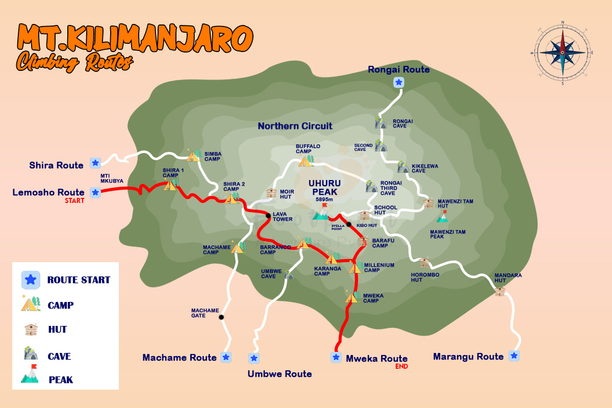
Why Choose the Lemosho Route for Mount Kilimanjaro?
The Lemosho Route stands out for its remote start, stunning views, and optimal altitude acclimatization. Here’s why it’s a top choice:
- Gradual Altitude Gains: Starts low at around 2,100m (6,890ft), allowing better adaptation to high elevations.
- Scenic Diversity: Traverse rainforest, moorland, alpine desert, and arctic zones with panoramic Shira Plateau vistas.
- High Success Rates: 85-90% summit success due to extended itineraries.
- Remote and Less Crowded: Begins on the western side, offering wildlife sightings like elephants and buffalo.
- Flexible Durations: 7-9 day options for varying fitness levels.
- No Technical Skills Needed: Suitable for fit beginners with proper training.
Lemosho Route Altitude Profile and Key Facts
The Lemosho Route altitude spans from 1,850m (6,070ft) at the base to 5,895m (19,341ft) at Uhuru Peak. Total distance: approximately 70 km (42 miles). Here’s a quick overview:
| Feature | Detail |
|---|---|
| Starting Altitude | ~2,100m (6,890ft) at Lemosho Gate |
| Summit Altitude | 5,895m (19,341ft) |
| Total Elevation Gain | 16,000-17,000ft |
| Duration Options | 7-9 days |
| Success Rate | 85-90% |
| Best For | Beginners seeking high success and views |
| Accommodations | Camping (tents, mats, mess tents) |
This profile reduces altitude sickness risks by following a “climb high, sleep low” approach, especially around Lava Tower (4,600m/15,092ft).
Day-by-Day Lemosho Route Itinerary with Altitudes
Our 8-day Lemosho Route itinerary at Mount Kilimanjaro Guide maximizes acclimatization. Altitudes are approximate and may vary slightly.
| Day | Route | Altitude Range | Distance | Hiking Time | Highlights |
|---|---|---|---|---|---|
| 1 | Lemosho Gate to Mti Mkubwa | 2,100m to 2,650m (6,890ft to 8,694ft) | 6km | 3-4 hours | Rainforest trek, wildlife |
| 2 | Mti Mkubwa to Shira 1 Camp | 2,650m to 3,610m (8,694ft to 11,844ft) | 8km | 5-6 hours | Emerge into moorland |
| 3 | Shira 1 to Shira 2 Camp | 3,610m to 3,850m (11,844ft to 12,631ft) | 7km | 3-4 hours | Shira Plateau views |
| 4 | Shira 2 to Lava Tower to Barranco Camp | 3,850m to 4,600m to 3,950m (12,631ft to 15,092ft to 12,959ft) | 10km | 6-8 hours | Acclimatization at Lava Tower |
| 5 | Barranco to Karanga Camp | 3,950m to 4,035m (12,959ft to 13,238ft) | 5km | 4-5 hours | Barranco Wall climb |
| 6 | Karanga to Barafu Camp | 4,035m to 4,673m (13,238ft to 15,331ft) | 4km | 3-4 hours | Alpine desert, summit prep |
| 7 | Barafu to Uhuru Peak to Mweka Camp | 4,673m to 5,895m to 3,100m (15,331ft to 19,341ft to 10,171ft) | 12km | 10-14 hours | Summit at dawn, descent |
| 8 | Mweka Camp to Mweka Gate | 3,100m to 1,640m (10,171ft to 5,381ft) | 10km | 3-4 hours | Forest descent, certificate |
7-Day vs. 8-Day Lemosho Route: Altitude Comparison
Choose based on your experience:
| Factor | 7-Day Lemosho | 8-Day Lemosho |
|---|---|---|
| Success Rate | 80-85% | 85-90% |
| Acclimatization | Good | Excellent (extra rest day) |
| Daily Altitude Gain | Higher intensity | More gradual |
| Cost | Lower | Slightly higher |
| Recommended For | Experienced climbers | Beginners or max success |
At Mount Kilimanjaro Guide, we recommend the 8-day for optimal Lemosho Route altitude management.
How Hard Is the Lemosho Route Altitude Challenge?
The gradual profile makes it manageable, but prepare for high elevations. Follow a 12-week training plan:
- Weeks 1-4: Build endurance with 8-10km daily walks.
- Weeks 5-8: Add elevation (500m+ gains).
- Weeks 9-12: Simulate with back-to-back hikes, 10kg pack.
Focus on cardio, strength, and downhill training to handle the Lemosho Route altitude demands.
Packing List for Lemosho Route Altitudes
Tailored for varying elevations via Mount Kilimanjaro Guide:
- Essentials: -10°C sleeping bag, layered clothing, waterproof jacket/pants, trekking poles.
- Altitude-Specific: Diamox (if prescribed), hydration bladder (3-4L daily), sun protection, thermal layers for summit.
Lemosho Route vs. Machame Route Altitudes
Compare popular options:
| Factor | Lemosho Route | Machame Route |
|---|---|---|
| Starting Altitude | ~2,100m | ~1,800m |
| Duration | 7-9 days | 6-7 days |
| Success Rate | 85-90% | 80-85% |
| Scenery | More remote | Varied but busier |
Is the Lemosho Route Safe at High Altitudes?
Yes, with low mortality (~0.0136%). Mount Kilimanjaro Guide ensures:
- Guides: KINAPA-licensed, daily health checks.
- Gear: Oxygen, hyperbaric chambers.
- Pacing: “Pole pole” to prevent AMS.
Over 50% experience mild symptoms; longer routes like Lemosho minimize risks.
Altitude Sickness on the Lemosho Route
Altitude sickness can affect anyone climbing Mount Kilimanjaro. Symptoms include:
Headache
Nausea
Dizziness
Loss of appetite
Fatigue
How Lemosho Helps Prevent AMS
Slow trekking pace (“pole pole”)
Extended acclimatization days
Excellent camp altitude layout
High-guide-to-client ratio (through trusted operators like Mount Kilimanjaro Guide)
Sleeping at Kosovo Camp – Higher Altitude Advantage
Some climbers choose to sleep at Kosovo Camp (4,900 m) instead of Barafu.
Benefits include:
Shorter summit push
Less traffic
Better acclimatization
More restful environment
However, Kosovo Camp is colder and windier, so it requires stronger altitude tolerance and special permits.
FAQs About Lemosho Route Altitude
What is the starting altitude of the Lemosho Route?
Around 2,100m (6,890ft) at Lemosho Gate.
How does Lemosho Route altitude affect success rates?
Its gradual gains yield 85-90% success, better than shorter routes.
What’s the highest point before summit on Lemosho?
Lava Tower at 4,600m (15,092ft) for acclimatization.
Can beginners handle Lemosho Route altitudes?
Yes, with training and the 8-day itinerary.
How to prevent altitude sickness on Lemosho?
Hydrate, pace slowly, consider Diamox; our guides monitor vitals.
Lemosho Route Pricing
Costs at Mount Kilimanjaro Guide range $2,000-$6,000 USD, including fees, guides, meals, porters. Group discounts available; contact for quotes.
Is the Lemosho Route altitude too high for beginners?
No. Lemosho is considered the best beginner-friendly route due to gradual altitude gains.
Does Lemosho Route require special acclimatization?
The route already includes built-in acclimatization days, making it one of the safest.
What is the highest point on the route?
Uhuru Peak – 5,895 meters, the highest point in Africa.
Does altitude affect sleep?
Yes, higher camps like Barafu or Kosovo may cause light sleep due to thin air.
Plan Your Lemosho Route Climb with Experts
For guided Lemosho climbs, altitude safety protocols, and complete itineraries, visit Mount Kilimanjaro Guide — your trusted partner for climbing Mount Kilimanjaro.