 {
Skip to content
{
Skip to content 
Explore Kilimanjaro National Park: Your Ultimate Guide to Adventure and Requirements
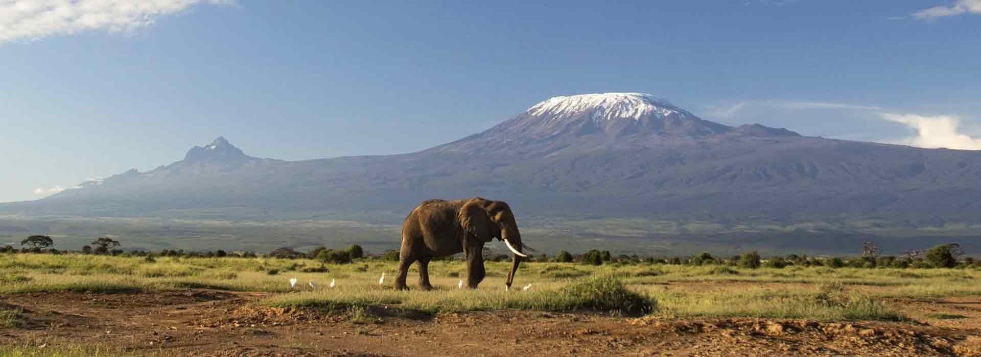
Kilimanjaro National Park, located in northern Tanzania, is a breathtaking destination that attracts thousands of adventurers each year. Home to Mount Kilimanjaro, the highest free-standing mountain in the world, the park offers diverse ecosystems, from lush montane forests to alpine deserts. Mount Kilimanjaro National Park is a Tanzanian national park located 300 kilometers (190 mi) south of the equator in the Kilimanjaro Region, Tanzania. The park is located near the region of Moshi. The park includes the whole of Mount Kilimanjaro above the tree line and the surrounding mountain forest belt above 1,820 meters (5,970 ft.). Kilimanjaro National Park covers an area of 1,688 square kilometers. The park is home to a diverse range of flora and fauna, including various species of trees, flowers, and animals. The park is also a popular destination for hikers and climbers, with many routes to the summit of Mount Kilimanjaro, the highest peak in Africa.
Key Requirements for Visiting Kilimanjaro National Park
- Permits and Fees: All visitors must obtain a climbing permit, which varies based on the route and duration of the hike. Fees contribute to park conservation efforts and infrastructure.
- Health and Safety: Acclimatization is crucial for a successful summit attempt. Visitors should be in good physical condition and consider consulting a healthcare provider regarding altitude sickness prevention.
- Guided Tours: Hiring a certified guide is mandatory for all climbers. Guides ensure safety, provide valuable insights about the environment, and help navigate the various trails.
- Equipment and Gear: Proper gear is essential for a safe and enjoyable experience. Recommended items include waterproof clothing, sturdy hiking boots, and personal safety equipment.
- Best Time to Visit: The ideal climbing seasons are January to March and June to October, offering the best weather conditions for trekking.
Wildlife and Flora
Kilimanjaro National Park is not just about the climb; it is also a sanctuary for diverse wildlife. Visitors may encounter species such as elephants, Cape buffaloes, and various endemic birds. The park’s unique vegetation zones enhance its ecological significance, making it a must-visit for nature lovers.
HOW TO GET TO KILIMANJARO NATIONAL PARK
The distance from Arusha City to Moshi Town is 123Km and it takes two hours (2 hours), reaching Marangu (Park Headquarters) from Moshi Town is 48 km and takes an hour (1 hour) drive. It is about 86 km from Kilimanjaro International Airport (KIA) to Park Headquarters (Marangu) by road and it takes one and a half hours (1Hr30Min). The park can only be reached by road
BEST TIME TO VISIT KILIMANJARO NATIONAL PARK
Mount Kilimanjaro can be visited throughout the year. However, the climate is most suitable for climbing in the dry seasons June-October and mid-December- February when the sky is clear and the mountain top is easily seen. Most people avoid April and May when there are heavy monsoon rains. However, the climb can be done provided you have proper climbing clothing and equipment.
ACCESSIBILITY:
The park is accessible by road to all the route’s main entrances. The park entrances are closest to Moshi town, making it the most preferred base for overnight before the climb.
Kilimanjaro National Park Attractions
These are places of interest where tourists can visit, typically for their inherent or exhibited natural or cultural value, historical significance, natural or built beauty, offering leisure, adventure, and amusement.
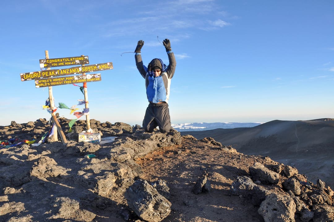
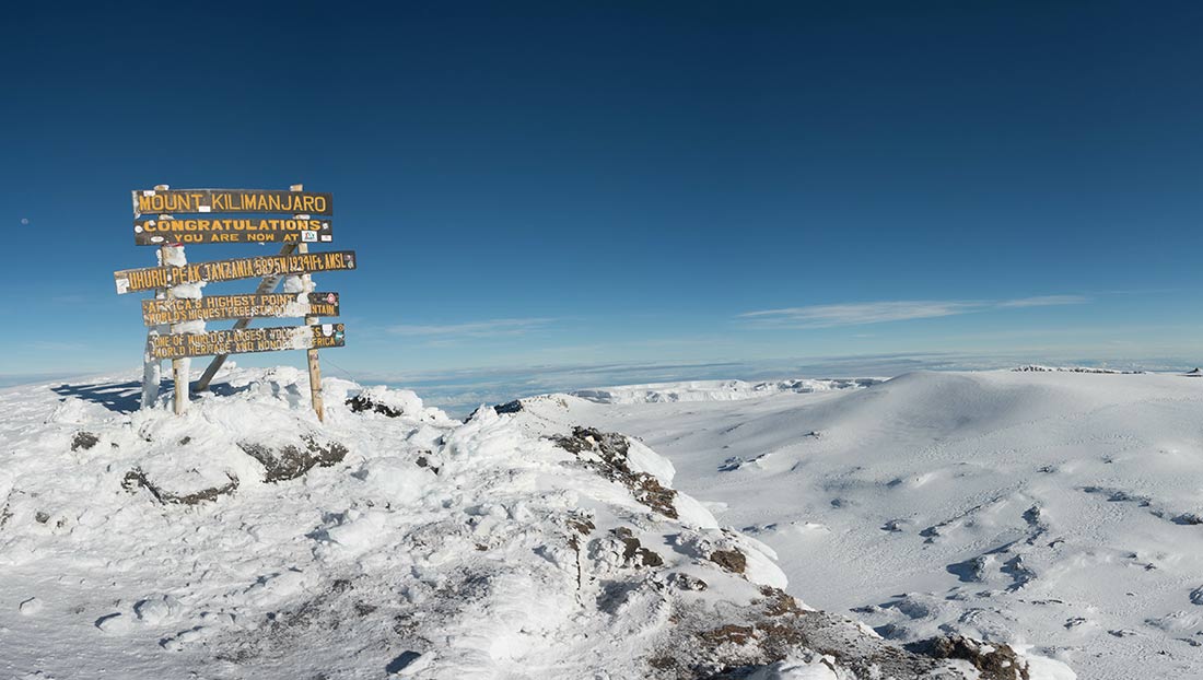
UHURU POINT
This is first highest point reached by climbers trying to conquer Kibo peak, 6km from Kibo hut (5895m). Visitors who reach this point are provided with gold certificates and recorded as successful climbers.
STELLA POINT
This is the second highest point reached by climbers trying to conquer Kibo Peak, 5.3km from Kibo hut (5739m). Visitors reached at this point are provided with silver certificates and recorded as successful climbers
ASH PIT
This is a recent volcanic landmark on the highest point of Africa (100,000 years). Visitors after reaching the summit may have a visit to this unique area
MAWENZI PEAK
Mawenzi, the rugged peak (5,149m), can only be attempted by technical climb. Only people with specialized knowledge, skills, and equipment are allowed
SHIRA PEAK
Shira with a height of 3962m, is the oldest peak that collapsed some 750 years ago while before collapsing was the highest of the three.
CATHEDRAL POINT – SHIRAPEAK
Cathedral is the point found on Shira Peak and can be climbed easily during a day hike or summit
SHIRA PLATEAU
After collapsing, the Shira Peak formed a plateau of outstanding scenic beauty on the mountain. This plateau has an open grassland, heath, and moorland with a large concentration of endemic plants including Senecio and lobelias. While on the plateau, one can visit the Shira central cone, the Cathedral, and the Needle. Several kinds of migratory mammals such as buffaloes, elephants, and elands use this plateau for feeding or salt-licking
ZEBRA ROCK
These stripped rocks are allocated along the Horombo -Kibo alternative trail 3Kms from Horombo huts. Visitors can have a short walk to these rocks as a part of the slogan “Go higher slip low”
VEGETATION ZONES
Mount Kilimanjaro supports a unique combination of eco-climatic zones that takes you to the equivalent of a trip from the equator to the Arctic in a brief tour. As one climbs Kilimanjaro, vegetation and weather change in response to the changing elevation. Between 1800 and 2800m, one goes through a montane forest. From 2800-4000m, vegetation is mainly heath and moorland composed of Helichrysum [Everlastings], Lobellia, and Senecio. From 4000-5000m, vegetation is alpine desert with sparse plants adapted to harsh conditions. The summit zone has temperatures below the freezing point throughout the year. The mountain peak is covered by snow all year round
MONTANE FOREST
A wide band of exceptionally beautiful montane forest encircles the whole of Kilimanjaro from about 1800 –2800m. About 96% of the water on Kilimanjaro originates from within this zone. The forest zone is worth a visit even if you are not climbing to the peaks. Marangu nature trails in particular take you through this forest belt. This belt supports several plant species, including endemic plants like Impatiens Kilimanjaro
MAUNDI CRATER
This crater is about 15 15-minute walk past Mandara huts on the Marangu route. On clear days, the crater provides a panoramic view of Lakes Chala, Jipe, and Nyumba ya Mungu, all of which derive their waters from the Majestic Kilimanjaro
LAUWO WATERFALL
Located along Marangu route 2.8Kms provides a spectacular experience while enjoying walking inside the thick montane forest
MARANGU WATERFALL
Located along Marangu Route 1 km provides a spectacular experience while enjoying walking inside the thick Montane forest.
LAKE CHALA
Lake Chala is located about 30 30-minute drive from Himo town. Although situated outside the Park, the lake is an important geological link to the park. It draws its water via underground streams that originate from Kilimanjaro. This deep freshwater lake can be visited before, or after climbing the mountain
ANIMALS
Mount Kilimanjaro inhabits 140 species of mammals; 7 primates, 25 carnivores, 25 antelopes, 179 bird species, and 24 species of bat. Hikes may view various animals including The Black and White Colobus Monkey, Blue Monkey, Forest Duikers, and small mammals like Myosorex zinkii which is endemic to Mt. Kilimanjaro. Buffaloes, Elands, and Elephants are the large mammals often seen on the Shira plateau and Rongai
Things to do in Kilimanjaro National Park
Kilimanjaro National Park offers a variety of activities for visitors to enjoy. The park is endowed with various tourism activities that visitors can do during their visit. The activities include; Mountain Climbing to the Summit (MC), Paragliding, Nature Walking Safaris (Short Walking Safaris (SWS), Long Walking Safaris (LWS), Mawenzi Technical Climbing (MTC), Picnicking, Filming, Non-Summit Bound Climbers, Crater Camping and Mountain Cycling (MB).
MOUNTAIN CLIMBING
Climbing to Kibo Peak takes 5 to 8 days depending on the route. The more days, the higher the possibility of conquering the summit. An extra day in any station above 3000m above sea level during the climb is highly recommended for adequate acclimatization. Six mountain trails can take a climber to the highest point in Africa, each route offering different attractions and challenges
MAWENZI TECHNICAL CLIMBING
Mawenzi is the second-highest peak on Mount Kilimanjaro. The rugged peak of Mawenzi (5,149 m) lies to the East. The top of its Western face is fairly steep with many crags, pinnacles, and dyke swarms. Its Eastern side falls in cliffs over 1,000m high in a complex of gullies and rock faces, rising above two deep gorges. The terrain of Mawenzi Peak makes it unreachable but by technical roped ascents (supplied by an individual client). Technical climbers can hike the present seven sub-peaks namely Nordecke 5136 m, Hans Meyer 5149 m, highest point, Purtscheller 5120 m, Borchers 5115 m, Klute 5096 m, Latham 5087 m, and Londt point 4945 m depending on the time and season of the year.
CRATER CAMPING
Camping in the crater provides a unique visitors’ night experience. While inside the crater tourists can visit the unique bench-shaped glaciers, the formation that can only be found at Mount Kilimanjaro.
MOUNT KILIMANJARO PARAGLIDING
Paragliders should feel at home at Mount Kilimanjaro as free-flying the world’s biggest free-standing mountain is now under operation.
MOUNT KILIMANJARO CYCLING (KILEMA ROUTE)
Tourists have a chance to cycle inside the park. There are two routes, one for summit-bound visitors (Kilema route) and the second one for nonsummit visitors (Shira plateau). These routes are equipped with picnic sites and resting points.
KILIMANJARO NATIONAL PARK PICNICKING
There are a total of 13 picnic sites along the hiking routes (Rongai starting, Kisambioni, Lauwo, wona, last water, Jiwe la Ukoyo, Machame half way, Jiwe la Mbula, Baranco junction, Morum, Uwanja wa ndege, Mgongo wa Tembo, Daraja Refu, Kilimamchele) that offer a spectacular view of the attractions found in and outside the park. They are the best places for taking packed meals on your way to the roof of Africa.
Marangu via Lauwo to Mandara Route (SWS) :
The Route starts from Marangu via Lauwo Waterfall to Mandara Hut then back to Marangu. The route covers a distance of 12 km.
Machame Gate to Machame Hut Route (SWS)
The Route starts from Machame Gate to Macham Hut and then back to Machame Gate. The route covers a distance of 11
Morum Barrier to Shira I Route (SWS)
The Route starts from Morum Barrier to Shira I then back to Morum Barrier Gate. The route covers a distance of 6 km.
Rongai Gate to Simba Camp
The Route starts from Rongai Gate to Simba Camp then back to Rongai Gate. The route covers a distance of 5 km.
Non-Summit Bound Climbers
Activities for non-summit bound climbers include:
• Visit to the waterfalls (Lauwo)
• Visiting the Shira Plateau
• Watching wildlife including high-altitude birds
• Walking through the Mountain Forest
• Day walk to Maundi crater in the park, Lake Chala, and cultural sites such as Kifunika and cultural camps in the villages around.
Lemosho Route (LWS)
This route is also for ascending located on the western side of the mountain and it is comprised of six stations of Mti Mkubwa then join the Londorosi route at Shira I.
Londorosi Route (LWS)
This is an ascending route located on the western side of the mountain and it is comprised of five stations namely Shira I, Shira II, Baranco, Karanga, and Barafu. It also offers the chance to use the Northern circuit and Western breach.
Machame Route (LWS)
This is an ascending route located on the South-West of the mountain and it has five stations namely Machame hut, Shira cave, Baranco, Karanga, and Barafu.
Mweka Route (LWS)
This is a descending route located on the southern side of the mountain. It comprised three stations namely Mweka Hut, High Camp (Millenium) anCampd Barafu. Visitors from Londorosi, Lemosho, Machame, and Umbwe descent use this route.
Umbwe Route (LWS)
It is an ascending route located on the southwest of the mountain and it has four stations, the Umbwe cave inside the forest belt and the other three after joining the Machame route at Baranco camp.
Kilema Route (LWS)
This route is for cycling. It has three stations namely Kilemamchele, Maua, and Kibo; it is two-way traffic.
Marangu Route (LWS)
This is an ascending-descending route with the provision of huts along the trail. It has three stations namely Mandara, Horombo, and Kibo. On the mountain stations, there are toilets, kitchens, dining, and rooms for clients. Booking through a licensed mountain tour operator is mandatory.
Rongai Route (LWS)
It is an ascending route with an option of using four or five stations depending on the choice of the climber. Visitors who ascend through this route will descend through the Marangu route. Option four stations include Simba camp, second cave, third cave, and school hut and the second option for five stations is Simba camp, second cave, Kikelelwa, Mawenzi tarn hut, and School hut.
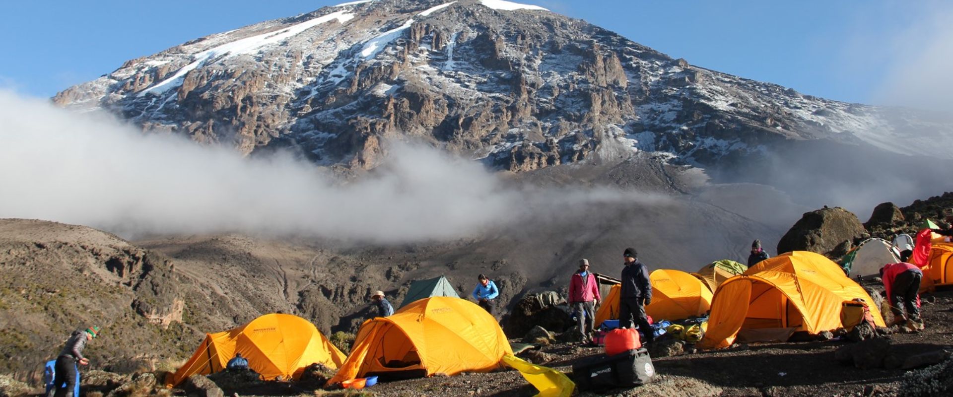
KILIMANJARO ACCOMMODATION FACILITIES
The Park provides a variety of accommodations ranging from Mountain huts, hostel, and 32 public Campsites. Booking for huts and hostels is done through licensed local tour operators
MANDARA HUT
It is the first station located along the Marangu ascending/descending trail 8kms from Marangu gate. The word Mandara originates from the name of the former Chief of Marangu whose name was Mandara. The reason is to keep the good memory of the chief Mandara who was in charge when the hut was opened in 1942. The hut has a capacity of 100beds for tourists and 200beds for guides and porters; therefore the total number of people is 300 at a time
HOROMBO HUT
This is a second station allocated 19 km from Marangu gate, at an altitude of 3720m amsl. The word Horombo originates from the name of the former Chief of the Rombo district (Keni) whose name was Horombo Urio. The reason is to keep the good memory of the chief Horombo. The hut has a capacity of 170 beds for tourists and 900beds for guides and porters; therefore the total number of people is 1,070at a time
KIBO HUT
This is the third base station located 28 km from Marangu gate at an altitude of 4720m amsl. It originates its name from the peak “Kibo”
MACHAME CAMP
This is the first camp along the Machame route located 11kms and at an altitude of 2835M amsl
SHIRA CAVE CAMP
This is the second camp along Machame route located 16kms from Machame gate and at an altitude of 3750M amsl
LAVA TOWER CAMP
This is a camp (used mostly for acclimatization) along the Machame route located 23kms from Machame gate and at an altitude of 4600M a.m.s.l
BARRANCO HUT CAMP
This is the fourth/third camp along the Machame route located 26kms from Machame gate and at an altitude of 3900M a.m.s.l
ARROW GLACIER CAMP
This is the third camp along the Machame route located 24 km from Machame gate and at an altitude of 4903M a.m.s.l. It is used by visitors who attempt their summit using the Western breach to Uhuru
KARANGA HUT CAMP
This is the fifth camp along the Machame route located 32 km from Machame gate and at an altitude of 3995M a.m.s.
BARAFU HUT CAMP
This is the sixth camp along the Machame route located 36kms from Machame gate and at an altitude of 4673M a.m.s.l
HIGH CAMP
This is the second camp along Mweka route located 13.5kms from Mweka gate and at an altitude of 3950M a.m.s.l
MWEKA CAMP
This is the last camp along the Mweka route located 10kms from Mweka gate and at an altitude of 3100M a.m.s.l. This camp is used by visitors after the summit
MTI MKUMBWA CAMP
This is the first camp along the Lemosho route located 3.5 km from Lemosho gate and at an altitude of 2650M a.m.s.l.
SHIRA 1 CAMP
This is the second camp along the Lemosho route located 10.5 km from Lemosho gate and at an altitude of 3610M a.m.s.l.
SHIA 11 CAMP
This is the third camp along the Lemosho route located 20.5 km from Lemosho gate and at an altitude of 3850M a.m.s.l.
MOIR HUT CAMP
This is the first camp located 10 km from Shira I camp and it is used overnight for visitors using the western circuit.
POFU CAMP
This is a second camp after Moir Hut where visitors overnight before joining the Rongai route at Third Cave or School Hut.
SIMBA CAMP
This is the first camp along the Rongai route located 5kms from Rongai gate and at an altitude of 2671M a.m.s.l
SECOND CAVE CAMP
This is the second camp along the Rongai route located 13 km from Rongai gate and at an altitude of 3450M a.m.s.l.
THIRD CAVE CAMP
This is the third camp along the Rongai route located 16 km from Rongai gate and at an altitude of 3800M a.m.s.l.
KIKELElWA CAMP
This is the third camp via Mawenzi hut along the Rongai route located 1 km from Rongai gate and at an altitude of 3600M a.m.s.l.
MAMWENZI TARN HUT CAMP
This is the fourth camp along the Rongai route located 21 km from Rongai gate and at an altitude of 4315M a.m.s.l.
SCHOOL HUT CAMP
This is the fifth base camp along the Rongai route located 31kms from Rongai gate (via Mawenzi tarn hut) and at an altitude of 400M a.m.s.l.
MAUA CAMP
This camp is under development and it will be used by visitors from the Rongai route. It is located adjacent to Horombo Huts
UMBWE CAVE CAMP
This is the first camp along the Umbwe route “the whisky route”
 WHAT IS THE COST OF CLIMBING KILIMANJARO INCLUDING FLIGHTS, TIPS, YOUR HEALTH, AND PARK FEES?
The average cost to climb Kilimanjaro is $2,000 to $4,000 the price varies from cheap, budget operators to large Western travel agents selling outsourced climbs at an inflated price. There are various, unavoidable fixed costs to any tour operator and if a climb seems too cheap, you’ve got to ask yourself why.
Where are they making ‘savings’ (read: compromises) and what impact might this have on your safety and comfort on the mountain? What about your crew? Staff expenses are the main way that cheap operators cut costs, by not paying a proper wage, and providing little (or no) equipment and gear. This won’t make for a happy team and gives rise to welfare issues.
The average cost of climbing Kilimanjaro from the USA, on an 8-day Kilimanjaro climbing program, will range anywhere between $5000 to $6000. Americans are subject to pay more in visa fees and their flights tend to cost more because of the extra distance.
Climbing Kilimanjaro costs from the UK £3000 to € 3500 on an 8-day Kilimanjaro climb program. This all-inclusive Kilimanjaro package is slightly cheaper due to logistics options open to Tanzania from the UK.
Climbing Kilimanjaro Cost from South Africa on an 8-day Kilimanjaro climb program should cost no more than R50,000. South Africans have much easier logistical access to Tanzania and do not regulate a visa upon entry.
Children under 13 could have their Kilimanjaro hike cost anywhere from $1,243 to $1,816. That’s because hikers within this age range are only to pay 70% of the total climbing Kilimanjaro costs due to the lower levies imposed by the Tanzanian government.
Tanzanian residents are subject to lower government fees and can find their Kilimanjaro cost range between $ 1,050 and $ 1,700.
The Kilimanjaro National Park Day Trip. The cost is $675 per person.


